
In the rolling hills and fertile valleys of Rwanda, where agriculture supports more than 70% of the population and contributes nearly 30% of the nation’s GDP, climate change is more than a distant threat. It is a lived reality. Increasingly unpredictable rainfall, prolonged droughts, and soil degradation have made farming ever more challenging, especially for smallholder farmers who depend on the land to feed their families and earn a living.
But amid these mounting pressures, an emergent wave of youth-led innovation is transforming climate risk into climate action.
Across Rwanda, young innovators are leveraging open environmental data and digital mapping tools to help farmers monitor deforestation, make smarter planting decisions, and adopt climate-smart farming techniques that sustainably protect the environment.
From Satellite Data to the Farmer’s Field
At the heart of this transformation is AGRIRESEARCH UNGUKA Ltd, a youth-led Rwandan startup that marries open satellite data with local weather information to create practical, actionable tools for farmers.
“We realized early on that data, when translated properly, can be a farmer’s best friend,” says Jean Claude Nkundimana, co-founder of AGRIRESEARCH UNGUKA. “Open environmental data allows us to show, in clear visuals, what is happening to forests and farmland over time, empowering farmers to take evidence-based action.”
The startup pulls freely available Earth observation imagery and climate datasets from sources like Digital Earth Africa, a open data platform that routinely provides high-resolution land use and vegetation data across the continent. These datasets, previously used mainly by scientists and policymakers are fed into digital tools that generate user-friendly maps and alerts.
Digital Earth Africa’s open data lets us monitor large areas without costly field surveys,” explains Dr. Kenneth Mubea, Capacity Development Lead at Digital Earth Africa. “Young innovators are now translating this into outputs that are meaningful at the community level.”
Complementing these tools, data from Meteo Rwanda, the national meteorological agency, provides localized weather forecasts and climate predictions. Real-time updates allow farmers to decide when to plant, irrigate, and protect crops from extreme weather events. “Meteo Rwanda is committed to delivering climate and weather information that is timely and accessible,” says Floribert Vuguziga, Senior Meteorologist at the agency. “When these forecasts are integrated into digital platforms used by farmers, the potential for climate resilience increases significantly”.
Turning Data into Decisions on the Ground.
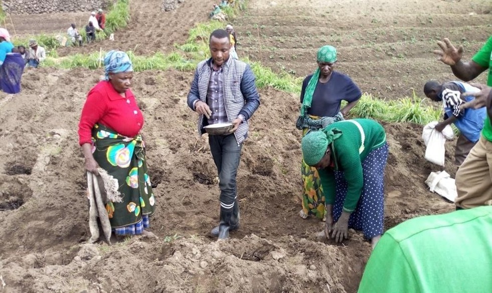
For farmers in districts like Kayonza and Burera, these digital tools have brought real change beyond theory.
“Before, planting was based on tradition,” says Marie Mukamana, a smallholder farmer and member of a local cooperative. “Now, we receive forecasts and map alerts on our phones or through agricultural advisors. We understand when to plant and how to protect our soil. Our yields are improving.”
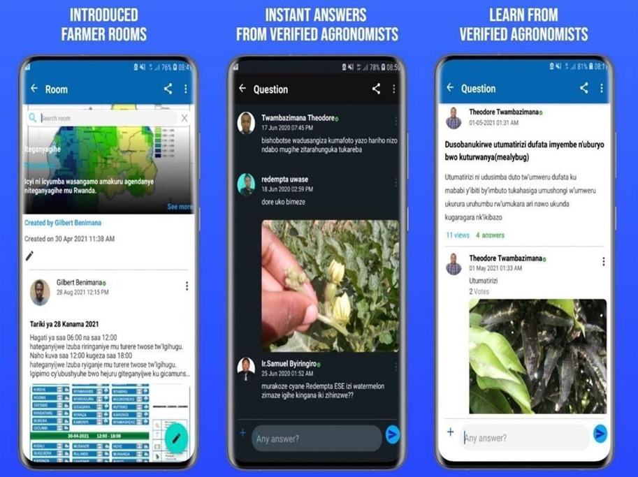
Through training sessions led by AGRIRESEARCH UNGUKA and partner NGOs, farmers learn to interpret maps that show changes in forest cover and land use, enabling them to make informed decisions about crop choice and conservation.
One such NGO focused on climate-smart agriculture explains, “Open data tools fill a gap that used to exist between scientific research and everyday farming practices. Farmers now have visuals that make sense to them in their own language.”
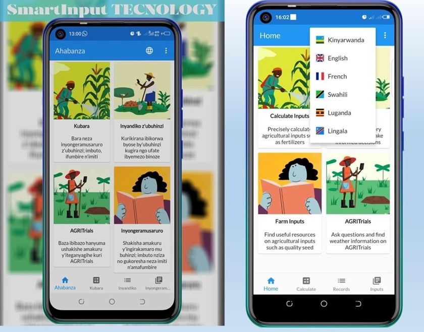
How Smart Input Technology Works
SmartInput technology is a digital system designed to collect, process, and interpret data efficiently to support decision-making. It typically integrates multiple sources of information, such as sensor data, weather forecasts, or user inputs, and automatically converts them into actionable insights. For example, in agriculture, SmartInput can gather soil moisture readings, rainfall data, and crop information, then provide farmers with tailored recommendations on when to plant, irrigate, or protect crops. The system often uses machine learning and predictive analytics to improve its suggestions over time, learning from patterns and outcomes to refine future guidance. By automating data analysis and presenting easy-to-understand advice, SmartInput reduces human error, saves time, and enhances productivity.
Digital Tools and National Climate Goals
These efforts align with Rwanda’s broader climate strategy. According to the Rwanda Climate Change Portal, the country has committed to a climate-resilient, carbon-neutral future, aiming to reduce emissions by 38% by 2030 compared with business-as-usual projections. Agriculture, forests, and land use form key pillars of this national agenda.
Forests themselves play a critical role: they help retain groundwater, protect soil, and support biodiversity. A 2022 environment report indicated Rwanda’s forests cover roughly 318,434 hectares of dense canopy, supporting both environmental services and rural livelihoods. However, agriculture expansion and pressure on land remain ongoing threats. By grounding climate action in digital tools, youth innovators are effectively supporting national climate targets while also bolstering community resilience.
Training and Adoption: From Cooperatives to the Countryside
Yet technology alone is not enough, adoption depends on education, access, and trust. Through collaborations with local cooperatives, NGOs, and government extension services, young innovators are leading training sessions across rural districts. For instance, the Participatory Integrated Climate Services for Agriculture (PICSA) program, run alongside Meteo Rwanda and the Ministry of Agriculture, has empowered more than 2,600 farmers to use climate information to make better farming decisions As Ministry of Agriculture and Animal resources mentions.

“Training makes the difference,” says Nyirabakiga Immaculée, a cooperative leader in Ngororero District. “Once farmers understand what the data means for their field, they begin to use it regularly.” For many smallholder farmers in Rwanda, agricultural decisions were traditionally guided by experience passed down through generations rather than by scientific data. Today, digital tools such as weather forecasts, soil maps, and crop monitoring apps are gradually transforming farming practices, helping farmers plan more effectively, reduce risks from climate variability, and improve yields. NGOs working in the region note that while digital adoption has shown promising results, significant hurdles remain. Inconsistent internet connectivity in rural areas, limited access to smartphones, low digital literacy among older farmers, and insufficient funding for scaling these initiatives beyond pilot programs all pose challenges. “We need continued investment in digital infrastructure and training,” notes Nomathemba Mhlanga, FAO Representative in Rwanda. “Without these, open data tools risk remaining underutilized, and the full potential of climate-smart agriculture and digital advisory services may never be realized.” Experts argue that bridging this gap requires not only technology deployment but also community engagement, capacity-building workshops, and continuous support to ensure farmers can fully interpret and apply the data to their day to day farming decisions.
Scaling Impact Across Eastern Africa
While the story is rooted in Rwanda, it holds broader regional relevance. Climate change does not respect borders, and neither should solutions. With open data platforms accessible across Eastern Africa, the potential exists to replicate successful models in neighboring countries such as Kenya, Uganda, and Tanzania.
Digital public infrastructure enables scalable climate solutions,” says Dr Lisa‑Maria Rebelo, Acting Managing Director and Lead Scientist at Digital Earth Africa. “What works in Rwanda can be adapted elsewhere, especially where agriculture is the backbone of the economy.”
In drought-prone areas of Rwanda’s Eastern Province, agroforestry projects are already showing early success. Initiatives trained over 470 farmers, planted 328,915 trees, and covered more than 2,069 hectares with climate-smart practices, demonstrating how digital tools and field action can reinforce one another.
The Role of Open Data in Fighting Climate Change
- Empowers communities, governments, and organizations with timely and actionable information.
- Informs decision-making by providing real-time climate and environmental data to guide planning and adaptation.
- Enhances transparency and accountability, making information accessible and tracking progress on climate goals.
- Supports climate adaptation through targeted interventions in agriculture, forestry, water management, and disaster risk reduction.
- Fosters innovation by encouraging developers, researchers, and NGOs to create tools and platforms leveraging climate information for local solutions.
- Promotes collaboration, strengthening partnerships between governments, civil society, and communities through shared and standardized datasets.
Gaps and Areas for Improvement in Rwanda
- Limited Access to Climate Information: Many farmers in rural areas rarely access forecasts or climate data due to low awareness and relevance of available information products. According to WeAdapt.
- Digital Infrastructure Challenges: Internet penetration remains modest, with around one-third of the population using the internet, limiting access to digital tools and real-time data in remote regions-according to Data Reportal,
- Low Digital Literacy: Many farmers, especially older ones, lack the skills to effectively use digital climate services, reducing the impact of open data initiatives, according to our field data.
- Funding and Resources: Scaling pilot digital projects nationwide requires more sustained financial investment to ensure long-term impact.
- Integration into Decision-Making: Open data is often underutilized because it is not yet fully integrated into local farming practices, policy planning, and climate adaptation strategies.
- Communication and Relevance: Climate information needs to be more locally tailored, using accessible channels such as mobile alerts or interactive platforms to reach vulnerable communities effectively.
Rwanda’s Commitments to the Use of Open Data to Fight Climate Change
- Build climate-resilient agriculture and ecosystems: Supporting 83,250 hectares and reaching about 170,200 farmers.
- Expand digital tools and open data: Internet access now covers 34.2 % of the population, enabling broader digital engagement.
- Promote climate-smart farming: Programs like PICSA have trained 2,600 farmers to use climate information for planting decisions.
- Align policies with climate goals: Rwanda’s NDC aims to reduce greenhouse gas emissions by up to 38 % by 2030.
- Foster partnerships: Collaborative initiatives with NGOs, research institutions, and international partners scale climate action nationally.
A Data-Driven Path Forward
Across Rwanda, the integration of data into agriculture and environmental management is transforming lives and landscapes alike. From the cooperative fields of Ngororero to the forests of the Eastern region, farmers and innovators are harnessing information to make smarter decisions, protect natural resources, and strengthen resilience against climate shocks. As Beatrice Cyiza, Director General of Environment and Climate Change at the Ministry of Environment, emphasizes, open data is more than a technical tool, it is a bridge between national policy, climate goals, and the everyday realities of communities. For farmers like Marie Mukamana, access to maps, forecasts, and soil information has turned uncertainty into confidence, allowing them to plan, conserve, and thrive. In a country where climate vulnerability is high and resources are limited, this data-driven approach is not just empowering, it is offering hope for a sustainable and resilient future.

Mukanyandwi Marie Louise